Hi, I am Abdulaziz!
I am currently pursuing a Master of Science degree at Stanford University, with a primary focus on Machine Learning and Optimization. Before joining Stanford, I was an AI Researcher at the Center for Complex Engineering Systems (CCES) at the King Abdulaziz City for Science and Technology (KACST) and Massachusetts Institute of Technology (MIT). I completed my Bachelor of Science degree in Electrical Engineering with a minor in Communication Systems from King Saud University (KSU). My research interests are at the intersection of Machine Learning, Optimization, Signal & Image Processing, and their applications in facilitating intelligent decision-making in sociotechnical systems. In my free time, I enjoy puzzle-solving and aviation.
Research Projects
Conditional Diffusion Models for Super-Resolution of Sparse Climate Data
 Figure: (Left) Sample urban area from Riyadh, Saudi Arabia (Right) Detected roads using the proposed method.
Learn more about this project
Access to high-resolution remote sensing imagery is critical for many energy planning applications, such as wind farm layout optimization. In this project, I investigated the viability of using the SR3 diffusion model for performing five times upsampling of the NREL WIND toolkit data.
Weakly Supervised Learning for Road Extraction from Satellite Imagery
 Figure: (Left) Sample urban area from Riyadh, Saudi Arabia (Right) Detected roads using the proposed method.
Learn more about this project
Labeling satellite imagery for semantic segmentation applications is time-consuming and expensive. Alternatively, we can utilize publicly available labels from services such as OpenStreetMap (OSM). In this project, I used publicly available geospatial datasets with recent advancements in weakly supervised learning to train deep learning models for extracting features such as roads from high-resolution satellite imagery.
Palm Tree Detection from High‑Resolution Satellite Imagery
 Figure: (Left) Sample of the proposed method detections (Middle) Al-Ahsa Oasis (Right) Detected palm tree density obtained using the proposed method.
Learn more about this project
The accurate detection of palm trees is critical for applications such as large-scale palm tree health monitoring and water consumption estimation. Traditional deep-learning approaches can produce accurate detections but require manually labeling large amounts of satellite imagery. On the other hand, processing the multispectral data collected by satellites using image processing techniques can result in robust detections, but at the cost of high false positives. In this project, I developed a hybrid algorithm that combines image processing and deep learning techniques to detect and count date palm trees from high-resolution imagery. Experiments on Al-Ahsa Oasis have shown that the algorithm is scalable, robust, and data-efficient.
Graph Theory for Automating Renewable Energy Deployment
 Figure: (Left) Sample of the graph representation (Right) Example of an optimal deployment produced by the proposed optimization model.
Learn more about this project
Accelerating the adoption of solar energy is hindered by the slow process of designing photovoltaic (PV) systems. Recent advancements in automated chip design have shown promising results on how optimization techniques can lead to designs that outperform those made by professional engineers and at a fraction of the time. In this project, I developed novel optimization workflows based on graph theoretical concepts to automate the design of PV systems. Experiments have shown that the developed workflow is scalable (~60 Seconds per building) and outperforms designs made by professional PV designers.
City-Scale Urban Scenes 3D Reconstruction from Stereo Satellite Imagery
 Figure: (Left) Satellite image of an urban area from Riyadh, Saudi Arabia (Right) Produced 3D model obtained using the proposed method.
Learn more about this project
3D models of urban structures are essential for applications such as energy estimation, outdoor comfort analysis, and urban planning. Generating compact 3D models of urban areas requires the presence of elevation models, which can be obtained through approaches such as airborne LiDAR. However, sending airborne missions to collect data is expensive and time-consuming. Satellite imagery provides a cheap and frequently collected alternative to tackle this issue. In this project, I am developing a pipeline for reconstructing compact and detailed 3D models of urban areas by combining recent advancements in photogrammetric techniques with stereo satellite imagery.
Reinforcement Learning for Electric Fleets Management
 Figure: (Left) Proposed hierarchical control pipeline (Right) Electric transportation network graph representation.
Learn more about this project
With the increased adoption of fleets that operate under the concept of mobility-on-demand (MoD), precise and scalable control of these systems becomes critical for reliable operations. In particular, coordinating the rebalancing and charging is essential for maintaining a high quality of service. However, traditional optimal control approaches for fleet management suffer from high complexity. In this project, I am developing a hybrid hierarchical control approach that combines reinforcement learning (RL) agents with model predictive control (MPC) algorithms to produce control laws that achieve the benefit of both of these approaches.
Drone Detection and Classification Using micro-Doppler Signatures
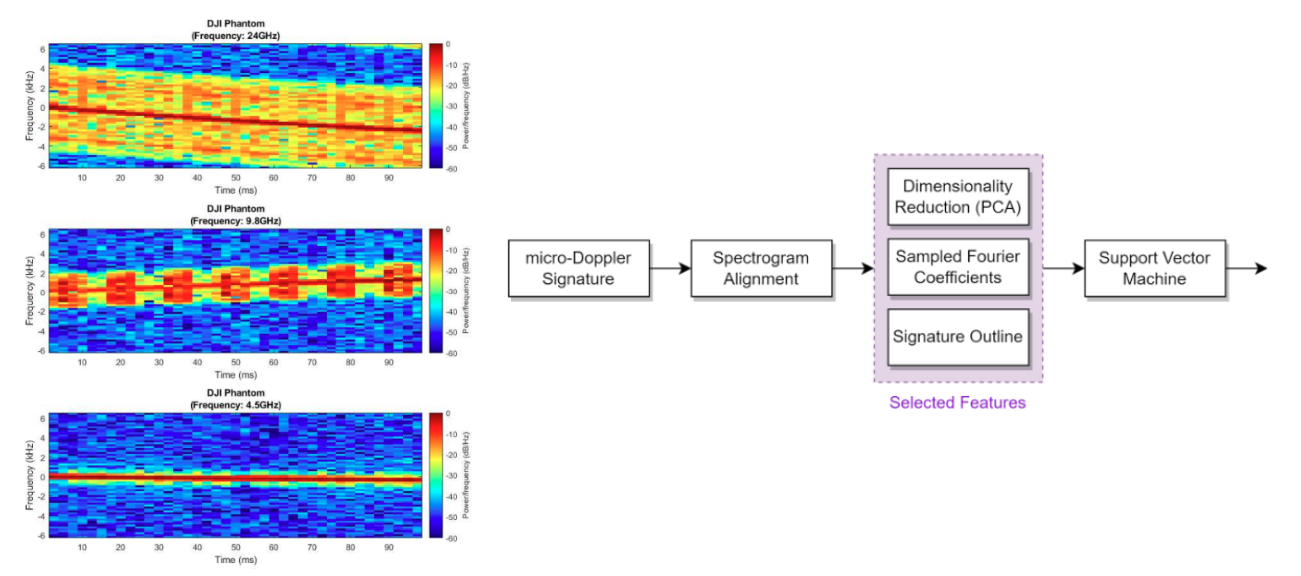 Figure: (Left) Simulated micro-Doppler signatures of drones using a point scatterer model (Right) Proposed detection pipeline.
Learn more about this project
Accurate detection and classification of flying targets such as drones and birds are critical for many security-related applications. The micro-Doppler phenomena allow for enhanced classification accuracy compared to approaches that rely only on temporal signal analysis. In this project, I developed an accurate computational model to simulate micro-Doppler signatures of drones and birds, built machine-learning classification pipelines, and implemented the algorithms on FPGAs.
A Computational Model For Response Time Assessment Of Public Health Facilities Under Congestion
 Figure: (Left) Simulation of a congested transportation network for Riyadh, Saudi Arabia (Right) Estimated response times throughout the city.
Learn more about this project
Accurate assessment of the response time of public health facilities is critical for improving the healthcare system. In this hackathon, we developed a computational model to simulate response times on a city scale. The model simulates congestion and applies a parallel processing workflow that computes the shortest paths from public health facilities to regions across the city. Our proposed solution achieved the 4th place in the helalthon hackathon sponsored by the Saudi Red Crescent Authority.
Last Update: May 2024 by Abdulaziz Alharbi - This website uses the academicpages theme.